New Hampshire Really Is New
During the Silurian Period,
The North American Plate (Laurentia) and the
European Plate (Baltica) continued
to do their thing - crashing into each other. They had been
doing this since the Cambrian Period,
tens of millions of years ago. In the process, an ancient ocean -
the Iapetus Ocean
[eye-AP-it-us] - was closing on either side of a volcanic chain of
islands. These islands, and the ocean floor sediments between
them and Laurentia, were
being steadily pushed up against the shores of the early North American
continent. The islands and hardened sediments finally were
attached through a process much like peanut butter being wiped off a
knife onto a slice of bread. This process is known as accretion to
geologists. In this way, these land pieces became the newest part
of North America.
But Wait, There's More
While Laurentia and Baltica were
closing in on each other, a third smaller tectonic plate was moving in
between them. This smaller plate was known as Avalonia.
Geologists are not exactly sure where Avalonia came from,
but their best guess is that it split from the supercontinent known as Gondwana.
Avalonia consisted of parts of Eastern New England, Nova Scotia,
Ireland and the British Isles. All of New Hampshire's land came
in this process of accretion brought
about by continental plates colliding with each other.
Of Falls And Formations
During the
Silurian Period, some metamorphic and igneous rocks
were formed well below the surface.
Thanks to the passage of lots
of time, and the weathering and erosion that goes
with it, these rocks are now exposed as surface bedrock.
The metamorphic
Silurian rocks are indicated by the green coloring on the Bedrock
Geologic Map of New Hampshire at right. These rocks are known as
the Fitchburg Formation,
named for the town in Massachusetts where they were first identified.
These rocks consist of schist [shist], quartzite [kort-zite] and
minor carbonate [kar-bo-nate] rocks. These now very hard and
erosion resistant rocks were once the muds (schist), layers of marine
skeletons (quartzite) or chalky carbonates that form from naturally
occuring chemical reactions in the ocean. These rocks have a high
iron content and appear rusty. A great place to see some of these
rocks are at Smalls Falls. These falls are visible from I-89
North, between exits 6 and 7.
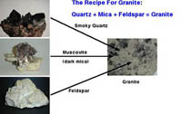
The igneous
Silurian rocks were formed miles underground by a pocket of magma that never
made it to the surface. As a result, it cooled slowly allowing
crystals of mica, feldspar and quartz to grow
before it solidified. If you find a rock with these three
elements in it, then you have found granite! As a general rule,
the larger the crystal grains are, the longer it took for that magma to
cool.
|
|
| Silurian New Hampshire |
|
 During the Silurian Period,
New Hampshire continues its northward drift from its position near the
South Pole in the Precambrian Period. Since New Hampshire
is located halfway between the Equator and the North Pole today, there
was still a long way to go. Fortunately, New Hampshire has had
over 400 million years to accomplish this move! During the Silurian Period,
New Hampshire continues its northward drift from its position near the
South Pole in the Precambrian Period. Since New Hampshire
is located halfway between the Equator and the North Pole today, there
was still a long way to go. Fortunately, New Hampshire has had
over 400 million years to accomplish this move!
(Click on the image for a closer look.)
Image Credit:
Christopher Scotese; scotese.com
|
| The
Recipe For Granite |
|
(Click on the image for a closer look.)|
Diagram
credit: Daniel E. Reidy
|
| The
Fitchburg Formation |
|
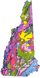
On the Bedrock
Geology Map of New Hampshire below, look for the metamorphic Fitchburg
Formation (green area) and igneous rocks (red, near seacoast) formed
during the Silurian Period. Where is your town in relation to
these rocks?
(Click on the image for a closer look.)|
Map
credit: New Hampshire Geological Survey
|
|

)
)
)