|
The Jurassic Period
[jer-AA-sick] was a very geologically active and exciting period
in New Hampshire. The rifting of the North American Plate from the
African and European Plates was starting to open up the brand new
Atlantic Ocean. Molten rock, or magma, would sometimes rise
up through the crust and erupt as a volcano and other times it just got
close to the surface. Keep in mind that "close to the surface" still
meant 3 to 5 miles below the surface, because on average, the Earth's
plates are about 20 miles thick. New Hampshire was still tropical, and
dinosaurs reigned supreme. If you attempted to go for a Jurassic walk
in the park, you would likely have ended up as some dinosur's light
snack.
Getting To The Root Of The
Matter
Knowing that granite forms 3 to
5 miles below the surface, that means all of the existing granite
outcrops on the surface today, whether on an exposed mountain top or in
a road cut, used to be that far below the surface. (See the Devonian
Period for more information.) If what we are seeing today used to be
that far underground, what happenned to all of the Earth's crust above
the granite since then?
As mentioned in the Triassic
Period, there had been no mountain building episode, or orogeny, on the
eastern edge of North America once the breaking up of Pangea started
nearly 180 million years ago. Since that time, only the forces of
weathering and erosion have been at work. Weathering and erosion are
slow processes, in terms of human lifespans, but 180 million years is a
very long time. Enough time, apparently, to wear away 3 to 5 miles of
solid bedrock and carry it away somewhere else. Where did all of this
bedrock go? Much was carried away by rivers, wind and gravity to
lowlands and the continental shelf or scoured and bulldozed by glaciers
and deposited elsewhere. (For more on the effects of glaciation in New
Hampshire, see the Pleistocene Period.)
Conway Granite
Some of the blobs of magma, or
plutons, that didn't make it to the surface during the Jurassic Period,
formed a unique salmon colored granite known as the Conway Granite. It
is called Conway granite because it was identified there first.
However, it is not limited to the Conway area. In fact, Conway Granite
can be found in Franconia Notch, among other places. It happens to be
the bedrock that Cannon Mountain is made of, which means that The Old
Man Of The Mountain was made of Conway Granite. Referring to the recipe
for granite (found on the Silurian Period page), we know that granite
generally contains the three minerals of quartz, mica and feldspar. The
feldspar in this case is pinkish/orange, or salmon in color, which is
what distinguishes this kind of granite from others.
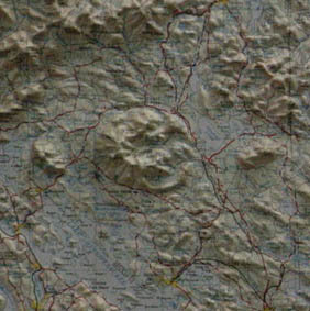
The Ossipee Mountain Ring Dike
Complex
During the Jurassic Period,
the land that would one day be New Hampshire experienced significant
volcanic activity. Some of the 'yellow blobs' discussed above represent
some classic, world famous (among geologists anyhow) nearly circular
volcanic mountains known as ring dikes. A dike
is a crack in the bedrock that is filled in with intruding material, in
this case, magma. A ring dike is a circular crack formed by the
collapse of a magma chamber's ceiling underground. The magma blobs
tended to be rounded in shape, not unlike the "lava" blobs in a lava
lamp. Magma erupted through these circular structures throughout
the state yielding several textbook examples of circular ring dike
mountains. The best known and largest example in New Hampshire are the
Ossipee Mountains in Moultonborough, Sandwich, Tamworth, Ossipee
and Tuftonborough seen in the box at right. Another excellent example,
albeit much smaller, is Mt. Pawtuckaway in Pawtuckaway State Park.
|
|
| Yellow Blobs |
|
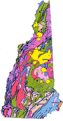 During the Jurassic Period in
New Hampshire, magma from the
Earth's interior did a fine job of taking advantage of the weak spots
created by the rifting of Pangea into what would become
today's tectonic plates. Take another look at the Bedrock
Geologic Map of New Hampshire below and look for the yellow blobs.
These blobs mark the places where the magma either came
close to the surface, or broke through it. Notice that the blobs
are rounded in shape and roughly lie in a straight line just a little
off of due North to South. Geologists disagree on the cause
for this pattern. Some think that New Hampshire slid over a 'Hot
Spot' as Pangea was rifting. The hot
spot would act like a blow torch and allow the magma to find its
way close to, and up to, the surface. Others believe the weak
spots were created by rifting which
happened to be in a straight line in this case. As in all
scientific theories, more evidence needs to be gathered to determine
which, if either, of the theories is more likely. During the Jurassic Period in
New Hampshire, magma from the
Earth's interior did a fine job of taking advantage of the weak spots
created by the rifting of Pangea into what would become
today's tectonic plates. Take another look at the Bedrock
Geologic Map of New Hampshire below and look for the yellow blobs.
These blobs mark the places where the magma either came
close to the surface, or broke through it. Notice that the blobs
are rounded in shape and roughly lie in a straight line just a little
off of due North to South. Geologists disagree on the cause
for this pattern. Some think that New Hampshire slid over a 'Hot
Spot' as Pangea was rifting. The hot
spot would act like a blow torch and allow the magma to find its
way close to, and up to, the surface. Others believe the weak
spots were created by rifting which
happened to be in a straight line in this case. As in all
scientific theories, more evidence needs to be gathered to determine
which, if either, of the theories is more likely.
(Click on the image for a closer look.)|
Image
credit:New Hampshire Geological Survey
|
Textbook
Volcanics In
New Hampshire |
|
The Ossipee
Mountain Ring Dike Complex is clearly evident in 3D on the map below.
Geologists the world over are familiar with this New Hampshire
mountain complex due to its nearly circular structure.
Below is a view of the Ossipee Mountains as viewed from the Southwest
at Geneva Point overlooking Lake Winnipesaukee in Moultonborough.
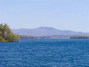 (Click on the image for
a closer look.)| (Click on the image for
a closer look.)|
Image
credit: Dan Reidy
|
|

)
)